X
Код презентации скопируйте его
GIS
Скачать эту презентациюПрезентация на тему GIS
Скачать эту презентациюCлайд 1
 VIRTUAL CONFERENCE - REMOTE SENSING PRESENTATION WITH RUSSIA: Moscow State University of Geodesy and Cartography (MIIGAiK) “On development of open-source portal for use of the remotely sensed data in emergency situations response applications scenarios” in Project 14.B37.21.1243 WGL-EGL Joint Tech Meeting September 19-21, 2013 Здравствуйте меня зовут…. я расскажу вам об одной из работ проводимых в МИИГАиК студентами и аспирантами по (название темы) под руководство Евгения Левина
Cлайд 2
 “Project 14.B37.21.1243” WGL-EGL Joint Tech Meeting, September 19-21, 2013 “Research and development of the opened networked geospatial instrument and educational content based on deployment remote sensing technologies for decision support in emergency situations of natural and human-induced nature.” Moscow State University of Geodesy and Cartography (MIIGAiK) Anton Bystrov, Alexander Grechishev, from Moscow В первой части доклада представлена общая информация о проекте с полным название ….., который мы начали 17 сентября 2012 года и заканчиваем в этом году
Cлайд 3
 “Project 14.B37.21.1243” WGL-EGL Joint Tech Meeting, September 19-21, 2013 Moscow State University of Geodesy and Cartography (MIIGAiK) Funding: the study was supported by The Ministry of education and science of the Russian Federation. The project is implemented under the guidance of the invited foreign scientist The project involves three PhD, 6 PhD students and 6 students from MIIGAiK Using space and UAVs remote sensing data in emergency situations Using open source technologies for making Emergency web-portal Creating multimedia educational online content Краткая тнформация о проекте представлена на экране. В качестве основных направлений проекта можно выделить использование данных ДДЗ из космоса, а также с БПЛА, при ЧС, примение технологий с открытым программным кодом для создания обучающего веб-портала при ЧС с использованием мультимедийного он-лайн контента.
Cлайд 4
 “Project 14.B37.21.1243” Moscow State University of Geodesy and Cartography (MIIGAiK) Town Alatyr, Chuvashia region Yandex maps (geoportal) EROS-B (22 April 2012) Представлены несколько примеров, формируемой Базы Знаний, по теме наводнений. Например: здесь вы можете затопление города Алатырь весной 2012 г.
Cлайд 5
 Town Tikhvin (near Saint-Petersburg) EROS-B (21 April 2013) Yandex maps (geoportal) “Project 14.B37.21.1243” Moscow State University of Geodesy and Cartography (MIIGAiK) На данном слайде затопление города Тихвин, недалеко от Санкт-Петербурга в этом году
Cлайд 6
 Settlement Korostovo EROS B (2 May 2013) Kosmosnimki.ru (geoportal) “Project 14.B37.21.1243” Moscow State University of Geodesy and Cartography (MIIGAiK) Аналогичный пример для населенного пункта Коростово Рязансокой области. Таким образом идеей нашего проекта является интеграция большого количества разноименных данных в Веб-портале для принятия решений при ЧС. Кроме коме космических снимков в проекте применяются данные БпЛА. Но об этом сейчас расскажет следующий докладчик.
Cлайд 7
 “Multi rotary UAV in Project 14.B37.21.1243” WGL-EGL Joint Tech Meeting, September 19-21, 2013 Moscow State University of Geodesy an Cartography (MIIGAiK) ”Vyacheslav Barbasov, Pavel Orlov, from Moscow
Cлайд 8
 unmanned aircraft «PTERRO» with camera CANON Tests on the MIIGAiKs geodesic test area UAV developed in MIIGAiK: SCB “Impulse” WGL-EGL Joint Tech Meeting, September 19-21, 2013
Cлайд 10
 Feature Quadcopter“Schmidt” Hexacopter“Juggernaut” Octocopter Topocopter“Dreadnought” Deployed size,length×width×height,mm 350х350х270 825х825х325 1100×1100×450 Transport size,length×width×height,mm 350х350х150 825х300х325 1100×1100×250 Speed of level flight, km/h 0÷55 0÷45 0÷50 Operating altitude,m 5÷250 10÷350 10÷450 Maximumaltitude, km 2 2 2 Flight duration, min Up to25 Up to20 Up to20 Maximum take-off weight, kg 2,5 6 10 Maximum payload, kg 0,8 2,5 4 Take-off weight, kg 1,4 3 5 Working temperature, °C -25 ÷ +50 -20 ÷ +40 -25 ÷ +50 Wind speed at launch,not more than,m/sec 6 8 10 Wind speedat an altitude,not more than, m/sec 8 10 12 Size oflanding area,not less than,m*m 1×1 2×2 3×3 Servicemen 1-2 1-2 2 Engine(electric power),item 4 6 8 Additional route camera(resolution) (Control of the axes) No No Yes,(752x582), (2axes) Portable No Yes No Application Monitoring,security forces Monitoring Cartography, Monitoring Now the main focus of SCB “Krechet” is making of multirotor UAV. There are 3 drones, testing at the moment: small drone – Quadcopter “Schmidt”, which able to work up to 25 minutes and can fly through a window due to his size. Mid-size drone Hexacopter “Juggernaut” has mobile portable structure. His weight is just 3 kg, so he can fly up to 20 minutes with a payload of 2 kg. And, of course, big drone Octocopter Topocopter “Dreadnought”. He can lift up to 4 kg and has a route camera.
Cлайд 11
 Multirotor UAV, which is developed in SCB MIIGAiK «Krechet», – octocopter «Dreadnought». This drone can be used to receive snapshots, applicable in map (or site plan) creating/updating, forming of digital terrain model, making 3D-models of buildings and objects, thermographic maps, panoramic surveying and also monitoring of natural and manmade emergencies development. WGL-EGL Joint Tech Meeting, September 19-21, 2013 “Multi rotary UAV in Project Project 14.B37.21.1243” Moscow State University of Geodesy and Cartography (MIIGAiK) Topocopter «Dreadnought» considered to be one of GIS content sources for filling Geoportal, which is developing in Geomonitoring Innovative Re-search and Educational Center’s project (MIIGAiK).
Cлайд 12
 Functions & elements of ground control When we use multirotor UAV in cartographic monitoring, it must be considered as a complex with its equipment (instrumentation) and payload. Its called UAS – Unmanned Aircraft System. UAS consist of payload and ground control. What is it for? - Automatic flight control; - Flight navigation; - Flight task input and processing; - Setting up a wireless link with an operator; Data receiving, processing and storage (Video and Telemetry); - Input of UAV control signals. “Multi rotary UAV in Project Project 14.B37.21.1243” Moscow State University of Geodesy and Cartography (MIIGAiK) WGL-EGL Joint Tech Meeting, September 19-21, 2013 When we use multirotor UAV in cartographic monitoring, it must be considered as a complex with its equipment (instrumentation) and payload. Its called UAS – Unmanned Aircraft System. By the way, UAV already has control system on board.
Cлайд 13
 Data, which is receiving by operators “Multi rotary UAV in Project Project 14.B37.21.1243” Moscow State University of Geodesy and Cartography (MIIGAiK) WGL-EGL Joint Tech Meeting, September 19-21, 2013 Data, which we receive from UAV, is sent to drone’s ground control, where it could be processed and sent to GIS data base.
Cлайд 14
 Flowchart of multirotor UAV «Dreadnought» data sending from it to GIS data base & end-user Camera (or other payload) Live View (1) PDA with iOS or Android (2) Laptop Commutation device with GIS Radio modem (3) Video channel 5.8 GHz (4) Video channel 1.3 GHz (5) First, data from UAV (from its payload actually) is collecting on mobile devices. Then, with the help of wireless links, it can be send to GIS data base, where it could be processed and shown to end-user in any part of the world.
Cлайд 15
 What can you find in UAV payload? - Digital camera (including Video camera) - Thermographic camera - IR-camera - Radiolocation equipment (Sonar) - Geiger counter “Multi rotary UAV in Project Project 14.B37.21.1243” Moscow State University of Geodesy and Cartography (MIIGAiK) WGL-EGL Joint Tech Meeting, September 19-21, 2013 There are several cameras, which were successfully used on “Dreadnought” as a payload: Canon 600D, Canon 5D Mark III, and also a thermographic camera TinyCam TC640 for land surveying. Besides, this drone can be equipped with other cameras and devices for ecological monitoring (for example radiolocation equipment and Geiger counter).
Cлайд 16
 Examples of UAV “Dreadnought” survey: Altitude: 100 meters Camera: Canon 550D Camera lens: 18 mm Overlap: 65% Flight duration: 8 minutes Flight speed on a route: 5 meters/sec Data processing, orthoimages creation, 3D terrain modeling etc are making on Russian software such as: Agisoft Photoscan&Stereoscan, Racurs Photomod, Scanex ImageProcessor, Panorama GIS-Karta. “Multi rotary UAV in Project Project 14.B37.21.1243” Moscow State University of Geodesy and Cartography (MIIGAiK) UAV “Dreadnought” surveyed a lot of test-objects, including geodesic ranges in Novgorod and Moscow regions.
Cлайд 17
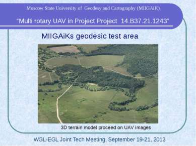 MIIGAiKs geodesic test area 3D terrain model proceed on UAV images “Multi rotary UAV in Project Project 14.B37.21.1243” Moscow State University of Geodesy and Cartography (MIIGAiK) WGL-EGL Joint Tech Meeting, September 19-21, 2013 3D model of Zaokskiy geodesic range.
Cлайд 18
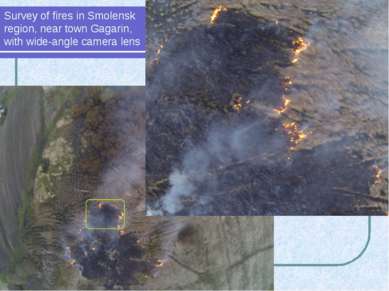 Survey of fires in Smolensk region, near town Gagarin, with wide-angle camera lens Multirotor UAV surveyed fires in Smolensk region
Cлайд 19
 The ways of multirotor UAV usage in environment monitoring: Cartographic monitoring Topographic survey Multispectral survey Thermographic survey Geology Cadastre (stereo image) Emergency control Tasks of agro-industrial complex Snapshots for 3D modeling Agriculture: control of farms & fields condition Ecological monitoring: - radiation; - chemical pollution; - bacteriological pollution. “Multi rotary UAV in Project Project 14.B37.21.1243” Moscow State University of Geodesy and Cartography (MIIGAiK) WGL-EGL Joint Tech Meeting, September 19-21, 2013
Cлайд 20
 Usage of results in studying & education Experience of UAV development, its usage and data processing embeds in educational program of MIIGAiK. One of the main tasks of our project is a development of special educational courses. “Multi rotary UAV in Project Project 14.B37.21.1243” Moscow State University of Geodesy and Cartography (MIIGAiK) WGL-EGL Joint Tech Meeting, September 19-21, 2013
Cлайд 21
 “On development of open-source portal for use of the remotely sensed data in emergency situations response applications scenarios” WGL-EGL Joint Tech Meeting, September 19-21, 2013 Moscow State University of Geodesy and Cartography (MIIGAiK) Igor Kostrukov, Eugene Stovolosov from Moscow Добрый день, уважаемые коллеги. Меня зовут... и я хотел бы рассказать вам о нашем геопортале. За основу взята технология Leaflet, которая позволят проводить работы с картами пространственными данными.
Cлайд 22
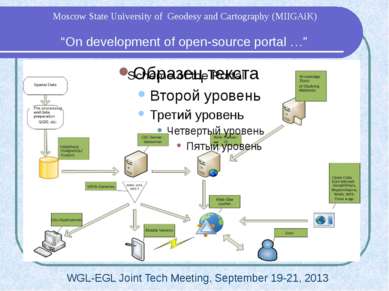 WGL-EGL Joint Tech Meeting, September 19-21, 2013 “On development of open-source portal …” Moscow State University of Geodesy and Cartography (MIIGAiK) На данном слайде представлены схема работы портала
Cлайд 23
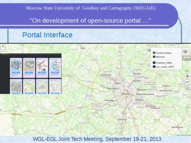 Portal Interface WGL-EGL Joint Tech Meeting, September 19-21, 2013 “On development of open-source portal …” Moscow State University of Geodesy and Cartography (MIIGAiK) Основными операциями являются: добавление, удаление слоев. Галерея слоев, меню выбора слоев и определение местоположения. Портал позволяет работать с тайловыми, WMS и WFS слоями
Cлайд 24
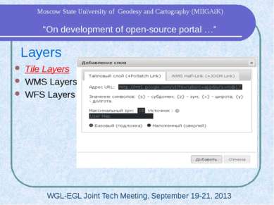 Layers Tile Layers WMS Layers WFS Layers WGL-EGL Joint Tech Meeting, September 19-21, 2013 “On development of open-source portal …” Moscow State University of Geodesy and Cartography (MIIGAiK) Так выглядит меню добавления тайлового слоя карты. Задаем ссылку на слой, тип карты и т.д.
Cлайд 25
 Layers Tile Layers WMS Layers WFS Layers WGL-EGL Joint Tech Meeting, September 19-21, 2013 “On development of open-source portal …” Moscow State University of Geodesy and Cartography (MIIGAiK) Так выглядит меню добавления WMS слоя карты. Задаем ссылку на слой, тип карты и т.д. Про WFS завтра добавлю слайд
Cлайд 26
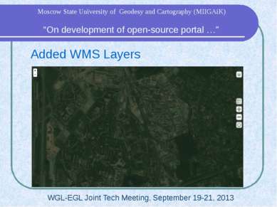 Added WMS Layers WGL-EGL Joint Tech Meeting, September 19-21, 2013 “On development of open-source portal …” Moscow State University of Geodesy and Cartography (MIIGAiK) Результат добавления WMS слоя
Cлайд 27
 Portal on Mobile Devices Based on “Phonegap” by Cordova Could save map layers and show it in off-line mode Better geolocation WGL-EGL Joint Tech Meeting, September 19-21, 2013 “On development of open-source portal …” Moscow State University of Geodesy and Cartography (MIIGAiK) Кроме стационарных ПК тестировалась возможность отображения карт на мобильных устройствах. За основу взята технология PhoneGap от Cordova, что позволило добиться стабильной работы портала. Так же есть возможность просмотра сохраненных карт оффлайн и более точное определение местоположения.
Cлайд 28
 3D Data Based on Web-GL technology Spatial Data from UAV 3D models from Photoscan WGL-EGL Joint Tech Meeting, September 19-21, 2013 “On development of open-source portal …” Moscow State University of Geodesy and Cartography (MIIGAiK) Еще одной возможностью портала является отображение трехмерных моделей местности через веб-браузеры. Для этого используется Web-GL + Three.js. Сами модели создаются в ПО Photoscan


